IN THE LAND OF THE YAK - Langtang...
One of the most beautiful valleys in the world, Langtang, to the north of Katkmandu attracts trekkers from the across the world. It is a pity, however, that not many Indians are aware of the wonders this region has to offer, says Rangan Datta 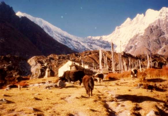 To the north of Kathmandu lies the valley of Langtang-the “Land of the Yak.” Legend has it, that once a lama lost his yak and followed it up the Langtang River. The animal died at a place called Langsisa, but the lama, wanting the hide, skinned it and spread it on a rock to dry. The skin, however stuck fast to the rock and the remains are rumoured to be still there for all to see! There in lies the mystery of its name, for lang stands for “yak” while tang means “to follow”. To the north of Kathmandu lies the valley of Langtang-the “Land of the Yak.” Legend has it, that once a lama lost his yak and followed it up the Langtang River. The animal died at a place called Langsisa, but the lama, wanting the hide, skinned it and spread it on a rock to dry. The skin, however stuck fast to the rock and the remains are rumoured to be still there for all to see! There in lies the mystery of its name, for lang stands for “yak” while tang means “to follow”.
My journey to the land of the yak started from Kathmandu vi Syabru Bensi on a bus so crowded, that passengers had to sit on the roof. The metalled road up to Trishuli gave way to a dirt road and that was one bumpy ride! At Dunche, the gateway to to Langtang National Park, our baggage was submitted to a spot-check. Paying the entry fee(Rs 100 per head for Indians and Rs 1,000 per head for other foreign nationals), we moved on to Syabru Bensi, two hours behind schedule.
A small town at the confluence of the rivers, Bhoti Koshi and Langtang, Syabru Bensi had several hotels catering to trekkers from all over the world. Halting at one of these for the night, I started off on my trek, the following morning, crossing both the rivers along with several of their tributaries. Reaching Bamboo Lodge by noon, I decided to call it a day. This village consisting of a cluster of lodges, lay right in the middle of a boulder zone created by a recent landslide. Through it flowed the Langtang River.
My trek, the following morning took me across an unstable bridge over a tributary and along a route skirting the Langtang River. Crossing a bridge at the site of a waterfall, I made my way along the river’s north bank, halting for the night at Ghoretabla(3020 m), a beautiful valley surrounded by jagged peaks and countless waterfalls, with a view of the Langtang River far below.
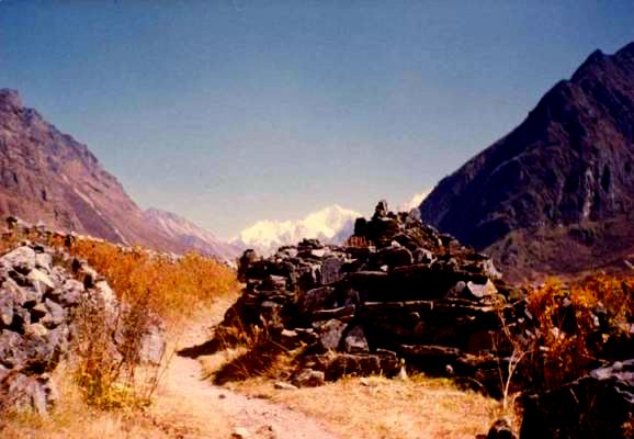
 Starting early the next day, I walked along the north bank of the river and reached Langtang, the headquarters of the National Park, in the afternoon. As I left it behind me, I came across a series of Mani walls stupas. Towering behind them in the distance were a row of snow peaks. The beauty of the sights sustained me all through my two-hour trek to Kyngin Gompa, a small village with a scattering of surprisingly well-equipped hotels (some even offered hot solar showers!) which serve descent, if expensive meals. This little “settlement” was presided over by a monastery and offered super views of the mountains – the Langshisa Ri to the east, the Langtang Liruing, the Kimshung and the Yansu Tsengi to the north and the Naya Kang the Ponggen Dokpu and the Ganchenpo to the south. Also visible from here were Kyangin Ri and Tsergo Ri, two peaks marked with pair flags and overlooking meadows dotted with grazing yaks. Starting early the next day, I walked along the north bank of the river and reached Langtang, the headquarters of the National Park, in the afternoon. As I left it behind me, I came across a series of Mani walls stupas. Towering behind them in the distance were a row of snow peaks. The beauty of the sights sustained me all through my two-hour trek to Kyngin Gompa, a small village with a scattering of surprisingly well-equipped hotels (some even offered hot solar showers!) which serve descent, if expensive meals. This little “settlement” was presided over by a monastery and offered super views of the mountains – the Langshisa Ri to the east, the Langtang Liruing, the Kimshung and the Yansu Tsengi to the north and the Naya Kang the Ponggen Dokpu and the Ganchenpo to the south. Also visible from here were Kyangin Ri and Tsergo Ri, two peaks marked with pair flags and overlooking meadows dotted with grazing yaks.
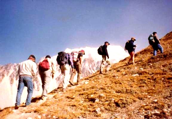
Excursions are organized regularly from Kyangin and I spent two days there so that I could avail of them. Setting off on the first day for Tsergo Ri, I jumped across a trickle of a tributary and followed the line of a ridge, pausing for a rest at a yak-shed. Continuing on my way, I reached the base of Tsergo Ri, a boulder zone which I had a hard time negotiating. I knew I was close to my goal, but try as I might (and I put in at least an hour’s effort), I couldn’t make it to the summit. I did enjoy the view though. Starting off the next day for the summit of Kyimoshing Ri (4620 m) and Kyangin Ri (4350 m), I followed the tributary, admiring Yansa Tsengi (6575 m) to the north and the Ponggen Dokpu peak (5930 m) to the south, with the Langtang River flowing around its base, before I reached the saddle, an area marked with cairns (stones placed one atop the other). The view from here was ….. heavenly.
 Visible from the base was an astoundingly beautiful array of peaks, but what drew my gaze away from them all, was the Lirung Glacier, cascading down the steep face of the mountain. Skirting the ridgetop to reach the peak of Kymoshinh Ri and admiring the string of colorful prayer flags all the way, I carried on along the ridgetop and arrived at the summit of Kyangin Ri, a rocky peak festooned with more prayer flags. Having reached my goal, I paused to savour the moment. For henceforth, the route would run all the way down, straight to Kyangin village. Visible from the base was an astoundingly beautiful array of peaks, but what drew my gaze away from them all, was the Lirung Glacier, cascading down the steep face of the mountain. Skirting the ridgetop to reach the peak of Kymoshinh Ri and admiring the string of colorful prayer flags all the way, I carried on along the ridgetop and arrived at the summit of Kyangin Ri, a rocky peak festooned with more prayer flags. Having reached my goal, I paused to savour the moment. For henceforth, the route would run all the way down, straight to Kyangin village.
On my way back from Kyangin I passed the monastery to reach the base of the glacier, where I stood reveling in the beauty of the nature. Then I took a different route back to Syabru, endig my trek at Dhunche, but not before buying some cheese from the factory at Kyangin.
My eight-day trek through the Langtang region took me through one of the most beautiful valleys in the world, embraced by mountains and snow-clad peaks which seemed to be within touching distances. The pity of it was that a family from Mumbai were the only other Indians I met on the route. Every one else seemed to be from Europe. Admittedly, the expenses involved in such a trek are high. What many of our countrymen being able to afford trips to far-off tourist hotspots around the world, however, one wonders how they can remain oblivious to a destination that is so near and a prime example of nature at its best. |